
The Great Glen Paddle Challenge is a 92km route up the Great Glen in Scotland. The Great Glen bisects Scotland between Fort William and Inverness and is connected by the waterways of the Scottish Canals Caledonian Canal. Various lochs along this route include the famous Loch Ness along with the lesser known Loch Lochy and Loch Oich.
While there is a well-known Great Glen Canoe Trail which suggests travelling the route over 4-5 days, we like to put the Challenge in Paddle Challenge with options to paddle the route over 1 or 2 days as part of a race! The Great Glen Canoe Trail has its own route map, which may be useful to paddlers and their support crews.
We would strongly recommend doing a little recon of your own to familiarise yourself with the route, work out the distances to checkpoints and timings for the day. This preparation will stand you in good stead to get to the finish line. Here is the Great Glen Google map Emma made when she did the race herself.
Additional route information can be found with Scottish Canals, or you may prefer to take a look at an OS map of the area which may give you some clues to the topography and the effect it may have on the prevailing wind.
There are various checkpoints along the route which will be manned by volunteers. Please remember to let them know your race number as you pass through the checkpoint. There are no mandatory rest periods, but the checkpoints do provide an opportunity for the race management to keep an eye on your welfare as you pass through the course.
In addition, the checkpoints are an opportunity to refuel, check in with your support crew and re-assess your life choices!
 We strongly recommend you practice carrying your kit around and transitioning from paddling, to walking. Get your kit sorted so you can take it off if needed and carry it on your back, then clip it back on again when you relaunch. Teams are welcome to help each other at portages, but solo paddlers have to be self-sufficient.
If we’re assuming the race is running from Fort William to Inverness, your portages come in this order (obviously in reverse order if the event is run from Inverness to Fort William).
1. Gairlochy – about 10km in, all flat canal so far, just getting warmed up, this is the longest portage. As you approach the lock, head to the left hand bank where there will be a couple of volunteers and the canoe pontoon (lower to the water). Exit the water and head up the grassy hill towards the road. At the road, turn right over the bridge and canal. It’s narrow here and the locals can include big logging lorries, so please watch for traffic and stay safe!
Once over the bridge, follow the canal path up to the basin which marks the start of Loch Lochy. There are pontoons here to launch from.
2. Laggan Locks – this is a beach exit, there will be a volunteer on the beach to guide you round the lock and back onto the canal. It’s a short walk of around 250m. Again a pontoon launch. There will be food and water available as this is also a checkpoint.

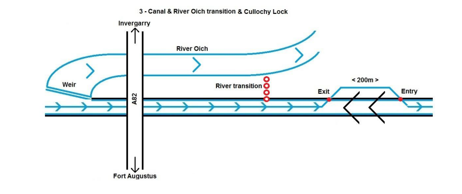
3. Culochy Lock – this wee lock sneaks up on you after you have stayed right at the top of Loch Oich. It’s a short portage of around 200m. Low canoe pontoon to exit, short walk and back in again.

4. Kytra Lock – Between Loch Oich and Fort Augustus, this wee lock always catches Emma by surprise. It’s just a wee one but at that stage in the day, it feels longer than it is! It is unlikely there will be a volunteer here, they will be waiting to cheer you in to Fort Augustus.
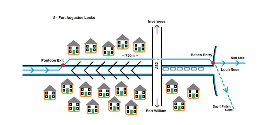
5. Fort Augustus Locks – a series of locks which connect the canal to Loch Ness. If you’re doing the non-stop, you’ll need to walk down the side of the canal, cross the main road (safely) and launch on the pontoons across from the tourist boats. Watch for the tourist boats and other craft manoeuvring here, they swirl up the water, so steer clear. We will have a couple of roving volunteers to help the non-stop paddlers safely navigate across the road to the water.

6. Dochgarroch Lock – A welcome break after paddling the length of Loch Ness! Duck in behind the tourist boats to the lower canoe pontoon. This is a shorter portage on flat, gravely ground and the last one before the Inverness finish.

Moy Bridge is the only known cast iron swing bridge in existence in the United Kingdom and is likely one of the oldest movable bridges of any kind in the United Kingdom as well. It’s just a wee bridge for pedestrians.
Gairlochy – not only a portage, also has a swing bridge. We will have volunteers helping where possible at this one. The bridge is narrow and the drivers aren’t fans of pedestrians at the best of times, nevermind when they’re carrying a 14ft (or similar) race board!
Laggan – Bottom of Loch Oich.
Top of Loch Oich – not to be confused with Bridge of Oich (an old bridge over the river). Don’t go down the river! Go under the swing bridge and continue on the canal. There are buoys marking the way. This is a good spot for supporters to cheer you on (there’s a small parking area and a low canoe pontoon)

Fort Augustus – Only really relevant to the one day paddlers. There are a series of locks here to transport boats from the canal down to Loch Ness (and vice versa). The main road is the last obstacle between the canal and the Loch. If you are paddling the route, you just portage round as per above and the traffic will be stopped so you can cross the road safely (please check before crossing!). Day two paddlers start on the loch side of the bridge, so no need to worry about this one.
Inverness – in the last canal stretch you come to two swing bridges very close together: Torvean & Tomnahurrich. One is very low and you will need to get low on your paddleboard (there is also a local kayak club in this area who may be out paddling on Saturday). These swing bridges are manned by Scottish Canals. The Great Glen Team will have a volunteer stationed here for a couple of reasons. First off – your safety! To coordinate with the Scottish Canals team and let you know if it’s safe to pass through. Secondly, to take your time if you are held up by boat movements so that the race management team can adjust your finish time accordingly.